|
|
New Providence Amateur Radio Club |
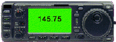
Club Simplex Frequency:
|
Menu:
ARRL Web Sites:Other Web Sites:Solar Conditions:
page last modified: Thu Oct 7 06:33:00 2021 PT |
Driving Directions to the New Providence Municipal CenterThe New Providence Municipal Center entrance is on Elkwood Street in New Providence, NJ. Please park in the Municipal Center lot off of Elkwood Street. Additional parking is on the surrounding side streets, but watch the signs. Do not park in any private lots or you risk a ticket/tow, especially in spaces reserved for the First Aid Squad. GPS Coordinates: 40.70740, -074.40405 From the East or North: Take Route 24 to Summit and the Summit Ave Exit. Follow Summit Avenue to Springfield Avenue (Rt 512) in the center of Summit. Turn right and take Springfield Avenue southwest to New Providence (about 3 miles). You want to turn right one block before the traffic light in the center of New Providence onto Academy Street (Academy is the right after Jane Road). Make right onto Elkwood Street and turn right into Municipal Center parking lot. From the South (Rt. 22 and Scotch Plains): From Route 22 (near Blue Star Shopping Center and Snuffy's), take Diamond Hill Road north to Mountain Avenue. Turn right on Mountain Ave and go about 1 mile to light at South Street. Turn left and proceed down the hill to the center of New Providence. At the second light, turn right onto Springfield Avenue. Then turn at your first left which is Academy Street. Turn right onto Elkwood Street and turn right into Municipal Center parking lot. From the West (Berkeley Heights): Follow Springfield Avenue through the traffic light in the center of New Providence at South Street. Turn at your first left which is Academy Street. Turn right onto Elkwood Street and turn right into Municipal Center parking lot. From Route 78 Eastbound: Take exit 44. At the bottom of the exit ramp, turn left onto Glenside Avenue. Go about mile and look for your first left, Glenside Road, which goes under Route 78 and up a hill to your first light. Continue through that light, Glenside becoming South Street. Continue down the hill to the second light at Springfield Ave. Turn right on Springfield and then turn at your first left which is Academy Street. Turn right onto Elkwood Street and turn right into Municipal Center parking lot. From Route 78 Westbound Take exit 43. Follow exit ramp, which will place you on Diamond Hill Road. Continue on Diamond Hill Road to the end of the roadway. Name changes from Diamond Hill Road to Union Avenue after second traffic light. Continue on Union Avenue which ends at Springfield Avenue. Turn right and continue for approximately 2 miles through second traffic light (the center of New Providence). Turn left onto Academy Street. Turn right onto Elkwood Street and turn right into Municipal Center parking lot. |